Home > 9. Operational/Synoptic > 9.3 WW3 Waves
9.3 Visualizing Modeled Wave Analysis Grids in IDV: WW3
|
|
| 1. WW3 is a very widely used and respected model, used by the military and global shipping interests. Go through this lesson now, but please come back to the site for more detailed study. Open NOAA Wave Watch III (WW3), and take some time to read about the model. | |
|
2. This is the map key to the products, at that website. Links to descriptions of the individual products are provided below it: GLOBAL, HURRICANE, GREAT LAKES, GLOBAL ENSEMBLE.
Click the WW3 Model Data Access link (top right corner). |
** |
| 3. And this is the Model Data Access page. Notice that most of the available products are in FTP servers. |  |
| 4. The remaining panels of this exercise use instead direct access to the files via THREDDS (not even mentioned above). Direct THREDDS access is provided by the US National Center for Environmental Prediction (NCEP) alongside the above products. We can use these data through the CATALOG feature in IDV. | |
| 5. Run the latest, properly set up version of IDV, and select a global map with PROJECTIONS > PREDEFINED > WORLD. |  |
|
6. On the dashboard page, make these settings to get to the NCEP THREDDS data products. If this is your first use of the catalog approach, take the time to do a little exploring.
Then click on the PLUS SIGN (+) beside WWW3-GLOBAL. |
 |
| 7. As far as this author knows, there is no generalized search function for the data types in the catalogs, only words/phrases in the HELP File. So unfortunately you must rely on tips from friends and MDL to identify data accessible to IDV. | |
|
8. You can open the various folders at WW3 to see what's there. Unfortunately the data items (blocked here in blue) are not particularly well-described by the online documentation. Just below begins a sequence of products identified by dates, which is what we usually expect.
NOTE: Please see that the earliest file in the date sequence was created in October 27, 2014. Today's date (for the author) is November 10, 2014, so the files are kept in place for about 2 weeks. Here's the simulations they contain:
Below, we'll see what they show. |
 |
|
9. Go to the latest simulation grid (today's date, in the case of the author). Burrow down into the folder until you find an item that causes the ADD SOURCE control to activate (gray to black) and select it.
Click on ADD SOURCE. |
 |
| 10. Find the wave grid you just selected in the DATA SOURCES panel. Right-click on it and select PROPERTIES. |  |
| 11. Select the SPATIAL SUBSET tab along the top. This is the main method to subset a global source to a specific area. |  |
|
12. Use the cursor to draw a box anywhere on the map. This is not your actual choice; it just activates the control.
Then enter the actual coordinates of the Liberia area (or whatever you want) in the 4 available spaces. NOTE: There are other controls (tabs along the top) you can use here or later. But the spatial subsetting must be done here. Now click OK. |
 |
|
13. Now you can open up the FIELDS and DISPLAYS PANELS to access the data. Make these choices, but come back later to explore all of them to see if you like something else better.
Then click on CREATE DISPLAY.
|
|
| 14. This data map should appear. If it's not quite right, then UNCHECK the box to hide it, then go back and make a new one. Keep trying until you understand what's happening, and you get it right. |  |
|
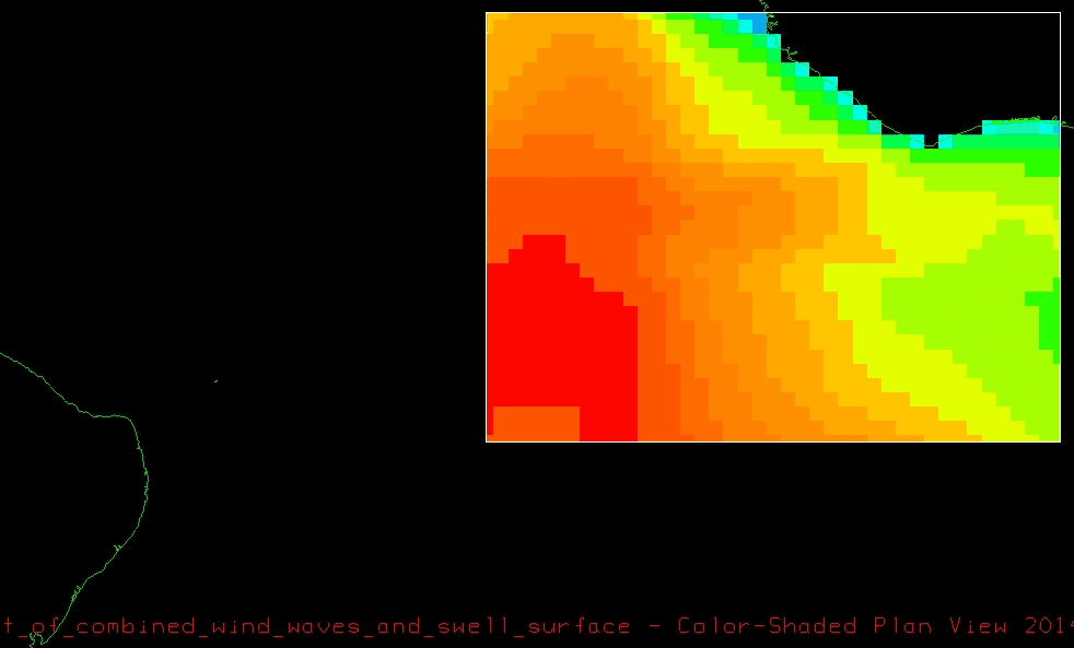
15. When you get the figure just right, then here's how you "fix" the colors. Click on the map name (right-hand column of maps) to open the control for it. Select COLOR TABLE > RADAR > DBZ(NWS) to get the most common rainbow spectrum of values.
Notice that the wave heights range from 0.6 m to 1.7 m (look at the top row beside the palette). |
 |
| 16. This gives a better distribution of colors so you can see the structure at all speeds. |  |
| 17. Click on the same control, but use CHANGE RANGE to pick rounded values, if you want. For example the author selected 0 and 2 |  |
|
18. This is not as colorful as the above figures, but it is scientifically better, because it uses values that could be used to accommodate other, related datasets, for purposes of comparison.
Select the range you like, no matter what the instructor says. |
 |
|
19. Now if IDV had a histogram function (it doesn't) then this is what it would show for these same data. You can use the method at 5.17 Creating a Histogram in Excel for IDV Grids.
Always examine display grid values as histograms, if you want to really understand what you have. |
 |
|
20. If you noticed above, we selected only one TIME when we used the CREATE DISPLAY control. Here we've gone back and used all of the times for the same geographic subset. You can see this by the long string of green time icons along the top-left side of the map.
You could click on the movie controls just under the small green boxes, to see an animation. |
 |
| 21. But we want to save the animation, for training and display purposes. So select VIEW > CAPTURE > MOVIE and follow the defaults to capture a TIME ANIMATION. |  |
| 22. And here is the author's animation of these data: waves_sea_swell_liberia_ww3_20141110_20141117.gif | |
| 23. Finally, how can you take the global or area data and extract a forecast for a particular point? Select DISPLAYS > DATA PROBE/TIME SERIES for all the data. |  |
|
24. Then a small dark cell will appear on your COLOR-SHADED PLAN VIEW map. You can move it manually, or by specific coordinates to a desired location. As you move it, this graph will change to show the wave forecast for that location within the grid.
THIS CAPABILITY IS ONLY FOR SCIENTIFIC TRAINING AND DEMONSTRATION, NOT FOR ACTUAL OPERATIONAL FORECASTING. DO NOT GET YOURSELF IN TROUBLE BY ATTEMPTING TO BECOME A WEATHER PERSON OVERNIGHT. |
 |
| 25. Now that you have the full series of grids and the probe time-series, you can save the complete collection with FILE > SAVE AS in the folder PRODUCS > IDV > XIDV with the filename waves_sea_swell_liberia_ww3_20141110_20141117.xidv | |
